
Acupuncturist Crystal hikes the Nootka Trail in 2025 (Part 2)
The following was written by our Acupuncturist Crystal Gilhooly, who hiked the Nootka Trail. Read on to learn more about the trail, preparations, and how to reduce the chance of injury. It is written entirely in her own words, and not by AI.
If you are looking to do the trail this year, hopefully this summary will be helpful for you to resource. As always, this is a summary of our own experiences, and you are always responsible for your own preparation and risk management.
Our Itinerary on the Nootka Trail 2025, July 1 through 6:
Day 1: Gold River to Third Beach
The beautiful and newly paved road winds from Campbell River along Strathcona Park, and finally passes through Gold River, and ending at the ferry dock and Air Nootka Float Plane office. We were greeted by Tyra and Scott, and even got a chance to leave early. Scott did a flyby of the trail, answering our questions and offering some landmarks for our journey — we couldn’t wait! Scott brought us safely into Louie Lagoon, where we followed the trail for 1km to emerge at Third Beach. Fair warning - the trail was muddy with a lot of blowdown, so although Scott said 30 minutes, it ended up taking an hour after we stopped for pictures and slowed down for mud and obstacles.
We emerged from the forest to an expansive beach with golden sand, blue waves, and crashing rock. There were already a few parties there, so we passed them and went around the corner to what seemed like and endless sandy beach and set up camp. There is a waste diversion toilet at this beach, and a stream to collect water from up high.
Food storage was a little awkward. Since folks were camped along the beach, a person has to go really far down the beach to hang their food. A couple times people used a bear hang that was far from their tent, but was basically on top of ours. This is why we used a Bear Vault, and we carried it hundreds of feet down the beach and stored it between fallen logs up high away from the surf.
While it was a little breezy in the afternoon, the windy completely settled at night, and we fell asleep to the sounds of the crashing waves, and woke to the sounds of birds. We had an approximate 12k day of hiking ahead of us and couldn’t wait to get started.

Day 2: Third Beach to Calvin Falls
There is a trail map published by John Baldwin that we purchased at our Air Nootka flight. It’s perfect and shows exactly what you need. I’m sure some folks will try to find online something to avoid buying it, but we recommend just to get it and support the work of the folks who make this trail happen. We climbed up the rock and into the forest, and then emerged on more beach. From here, we followed the tidal shelf at low tide, and walked what felt like endless beaches, and barely saw another soul the entire time. We were so enamoured with the expansive landscape, we barely notice the sun and wind burn on my legs that was developing from the sun reflecting off the ocean. More on that later. We took our time, making photos and videos and scanning the ocean for sea creatures. Our Garmin recorded 13.58km over 5h50m and a total ascent of 158m, including all breaks and non moving time. We absolutely could have gone faster but had no desire to.
The wind chased us to Calvin Falls, where we crossed the river at low-ish tide and stayed on the east. We found a few other parties struggling with the wind, as the insert of the falls creates a wind whipping effect that really only decreased after about 10pm. The beach is a sand beach, meaning that tent pegs don’t stay. Despite being behind a pre-made wind break, I had to use all ten tent pegs and anchor them with large rocks to avoid my tent tumbling right into the falls with all my gear in it. It absolutely tested the limits of my tent, and my patience. Luckily, the views make up for it. We climbed up the right side of the falls, where there is actually a sectre campsite or two above the falls in the forest. But make no mistake, it was just as windy down there. At the time of writing, the marine rope to assist going up and down the right side of the falls was frayed and re-tied, but there was still one section very frayed due to constant contact with rock edge. Proceed with caution, and avoid falling on this rope. Perhaps someone could forward this info to the folks who manage this section. The rock edges are possible to climb without a rope, but with the high risk of slipping on the way down, I would absolutely not recommend it.
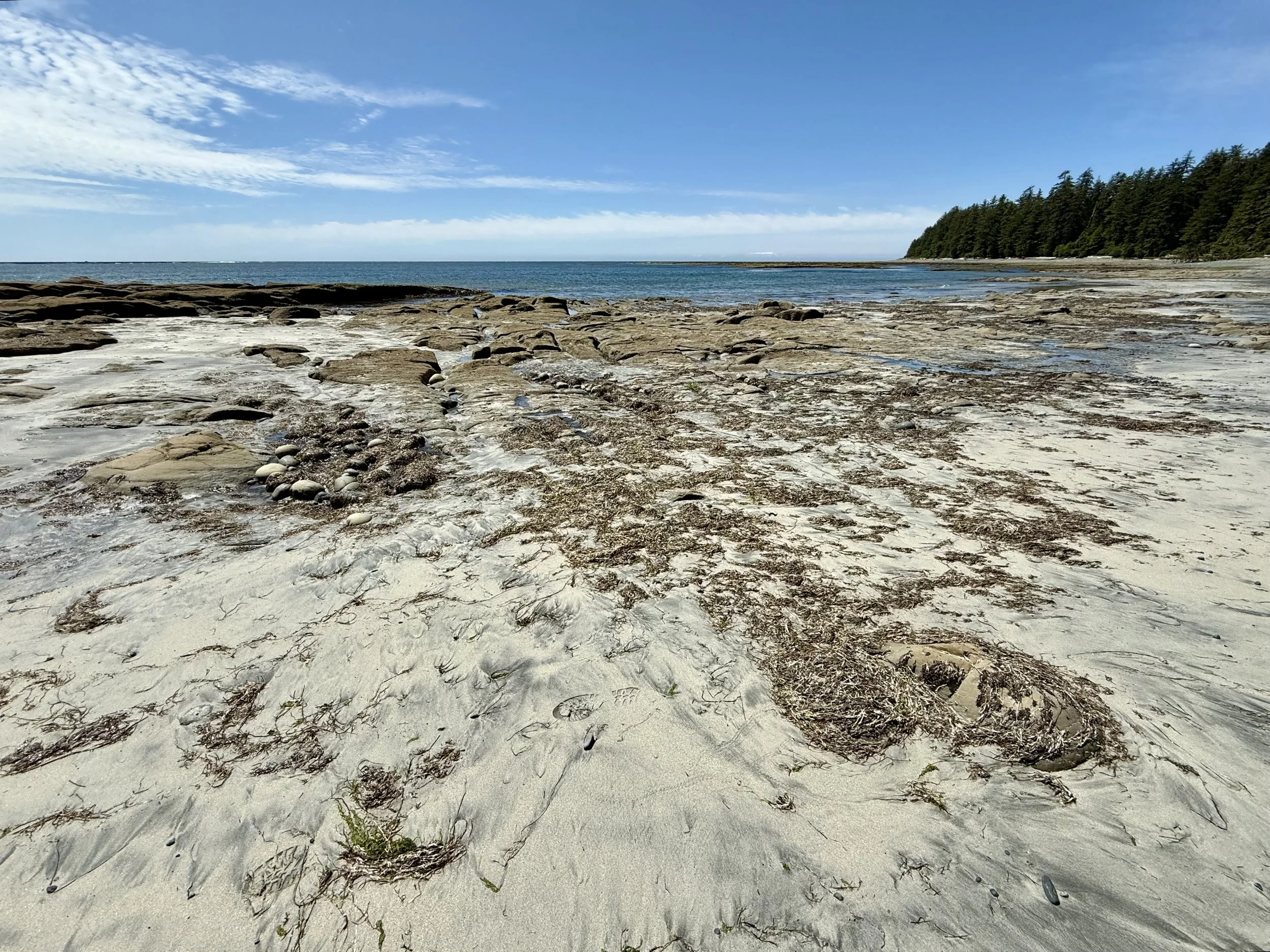
Tidal shelf at low tide
Day 3: Calvin Falls to Beano Creek
This is the day where everyone warns you about the pea gravel. It’s not just the pea gravel, but also the large quantities of various bundles of seaweed. We hiked along the shoreline, constantly evaluating the easiest route, as the pea gravel can really take it out of you. Lukily, with low tide, we were able to walk for long periods on the gorgous rocky tidal shelf. For this reason, you need to allow yourself more time than you think you need. You will find a constant supply of sea creatures, birds and…. bears! The bears come out when it is sunny to forage on the beach. The first bear we saw, we walked way out on to the tidal shelf to avoid, probably more than a one kilometer detour. The second bear we didn’t have the luxury without walking through slippery tidal swamp rocks, so we waited to the bear to head into the forest, and we gently passed. If it’s a sunny day with low tide - you are going to see bears.
Speaking of a sunny day, I really didn’t want to wear full pants, because of the gorgous weather, and took my chances with the shorts and gaitors again. Well, this proved to ba a painful decision, but I don’t really regret it. The sun and wind destroyed the front, right side, and posterior of my thighs and knees, leaving me with a hot red burn in most of the area. That night was a night of sun injury and inflammatories. The pants I had brought were just a bit too tight and a bit too hot. I would have packed lighter and breezier pants next time.
However, my jacket was the best gear choice ever. A heavy rain jacket from a well known company that has a big hood (big enough for a climbing helmet), and upper chest zippers and pit zips. It protected my arms, body, head and ears from the sun and wind, yes was vented enough to keep me cool and avoid me becoming cooked like Sous vide.
Eventually we rounded the corner for Beano Creek, named for the tiny pea gravel that looks like beans, or mung beans, or whatever variety you choose. There is great camping in the forest and on the beach. Ryan decided to camp on the beach, but I had enough of the wind and sun and went into the forest with my tent. There is a waste diversion toilet here, which was quite the luxury. Water from the creek was taken when it was flowing, and we avoided it at high tide when stagnant and clearly brackish. Our Garmin recorded us walking for 4h56m over 11.72km, but again, this includes a large bear detour, a bear delay, and all our snacks and photo stops.
The highlight for me was waking up early at 6am, getting my bear canister, and sitting down to a coffee, when at 6:15am a single wolf passed from north to south down the beach. We had seen tracks both previous days, and the wolf was travelling down the same track path, likely a habitual morning jog. When Ryan alerted me to the wolf, I quietly stood up and managed to get a shot of it heading away. It did notice us at one point, but went back to ignoring us pretty quickly.
The Beano water crossing was at a higher tide, but there was enough variation in the width of the river to allow us to find a good crossing the next day. So good that we crossed it multpile times to get a few videos of us doing it. This was such a memorable site - thanks Beano Creek!
Day 4: Beano Creek to Sunrise Beach
If there was one thing we would have changed about this trip (other than protecting my legs from the sun), it would have been adding an extra day in this section. Most trip reports encourage people to take 1.5 to two days in this section, and they are correct. It is the most diverse and complex section of the trail, and there are at least a dozen good campsites along the way, including at Callicum Creek (fresh water here, don’t skip it).
After crossing at Beano, you walk another kilometer or so and them come to a choice of an inland route or beach route. We had the tide in our favour, and then approached a cliffside with wet rope options to climb up. I was a little intimidated by this section, so I opted to use my climbing knowledge to use a clove hitch onto my backpack with a carabiner and then climb up, secure myself with the static line I brought, and then haul my bag up the side. It turned out to be way more work than had I just climbed the cliff with the rope, as Ryan then had to help my bag get under the extra secured rope and over another rock ledge. Good practice for me to use my knot knowledge, but probably an unnecessary delay.
There are at least 6-8 cliff scrambles, ranging from 6 feet high to 16 feet high on this day. You will need to climb and descend WITH YOUR BACKPACK, possibly in the rain. The weather we got was great - warm and sunny. This meant that the trail was less muddy and the rope climbs and cliffs were drier. Most have some version of a marine rope for assistance, but the rope may be of varying condition after being tugged and dragged across jagged rock faces and exposed to the elements, and by the time you get to it, could be partially shredded. Without a doubt, this is one area where people may feel apprehensive and wished they had more preparation. Part of the work I do at Elios Health is prepare people to get in shape to feel confident in these circumstances. If you want to know more about physical fitness to tackle rope ascents, please contact me.
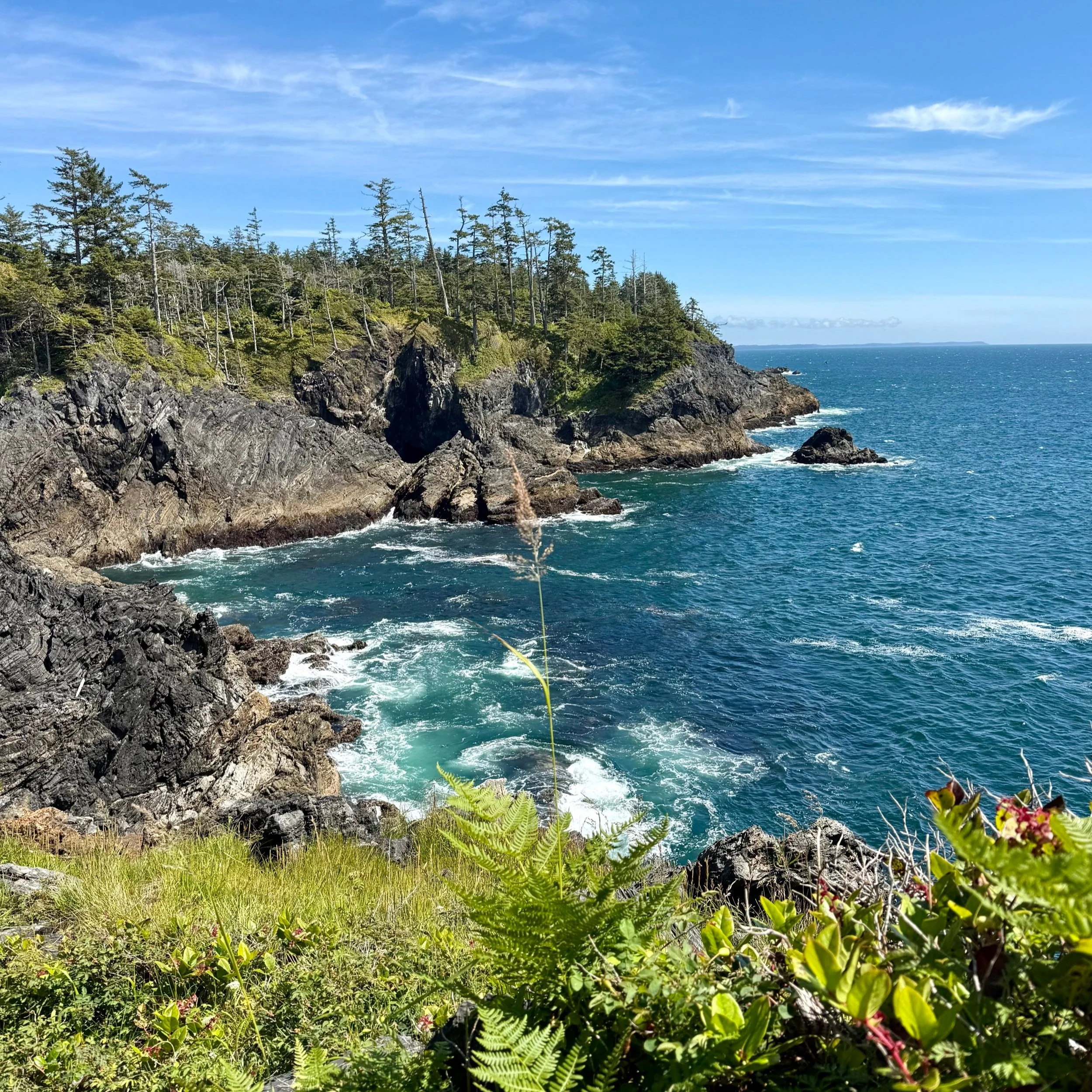
The entire day from Beano to Sunrise was clocked by Garmin at 13.39km, and we were on the trail (including our rope adventures, snacks and photos) for 8h46m. The micro-climates were spectacular - pocket beaches, sea caves, windy cliffs, sweet peas, eagles, wild roses, lakes and ponds, seals, and more. If you can take my advice, let it be this: make a stop in Callicum Creek, and add a day to your journey. This is not the place to just “tick” off your hiking list.
Many folks in other blogs talk about the forest sections going at 1km per hour. This is very accurate. I certainly didn’t think it was the hardest hiking or most technical hiking ever, it is just the aspect of climbing and ducking under logs, managing the rope climbs, and avoiding getting the boots sucked off by mud, in addition to the photos and side quests.
Sunrise Beach has a pond 100m to the west through the forest. The water is brown and filters brown but taste just fine. No issues. There are no toilets, so be prepared to dig a nice deep hole.

Day 5: Sunrise Beach to Sea Stack Beach
We wanted to save the most relaxing days for the end, and it was worth it. We had a nice gentle morning with no wind, and a beautiful sandy beach. We had nothing to do but wait for the tide to go down at the Lagoon Crossing. We packed up slowly, and then headed out. It’s worth noting that between Sunrise Beach and the Lagoon, there are lots of braided paths throughout this area, so keep your eyes active to pay attention to the flagging. We missed an obvious flag on the ground, leading us thorugh a tangly forest that we then had to backtrack through, adding about 40 min and an extra km to our journey. It didn’t matter, however, because the journey is so short. Including getting lost and filming multiple lagoon crossings, our 3.61km journey took 2h38m.
We arrived in the early afternoon at Sea Stack Beach with lots of time to set up camp and explore the beach at low tide. Many starfish and mussles and clams, birds, and otters abound. At high tide, you can see the otters diving for mussels and turning over to crack and enjoy them. I am grateful for Ryan working on this itinerary for us so that we could have these final two days of relaxation.

Day 6: Sea Stack Beach to Yuquot
We took nearly an hour (0h53m) to walk down the beach the next morning, to arrive to the Yuquot campground, where we paid the Nootka Trail Fee ($75 each person in cash) and spent the morning walking around the site. The Nootka Trail is on the unceded territory of the Mowachaht/Muchalaht First Nation. The church was closed, but there was a master carver on site to share traditional carving. There was also a relief lighthouse worker at the lighthouse, who gave us an explanation, and let us look around the site for a bit. We saw a deer!
Scott from Air Nootka came in to pick us up at noon, and we enjoyed the spectacular flight back to the Air Nootka office, and started our drive back from there.
Get Ready for the Nootka Trail
Are you ready to tackle the Nootka Trail, but have more questions? As Sports Acupuncturist, a huge portion of my work is non-needle consultation. I provide training plans and preparation strategies for hikers, climbers, and outdoor athletes. If you would like to work with me, you can book directly HERE, or email me.